Wide Worlds Snapshots

We help you to see the Whole World in Snapshots, And you follow us in your likes and comments/.

Wide Worlds Snapshots

We help you to see the Whole World in Snapshots, And you follow us in your likes and comments/.

Wide Worlds Snapshots

We help you to see the Whole World in Snapshots, And you follow us in your likes and comments/.

Wide Worlds Snapshots

We help you to see the Whole World in Snapshots, And you follow us in your likes and comments/.

Wide Worlds Snapshots

We help you to see the Whole World in Snapshots, And you follow us in your likes and comments/.

Showing posts with label ASIA. Show all posts

Sunday, 16 August 2015

Indonesia - The Wide Worlds Snaps

President: Joko Widodo (2014)

Land area: 699,548 sq mi (1,811,831 sq km); total area: 741,096 sq mi (1,919,440 sq km)

Population (2014 est.): 253,609,643 (growth rate: 0.95%); birth rate: 17.04/1000; infant mortality rate: 25.16/1000; life expectancy: 72.17

Capital and largest city (2011 est.): Jakarta, 9.769 million

Other large cities: Surabaya 2.787 million; Bandung 2.429 million; Medan 2.118 million; Semarang 1.573 million; Palembang 1.455 million

Monetary unit: Rupiah

Indonesia is an archipelago in Southeast Asia consisting of 17,000 islands (6,000 inhabited) and straddling the equator. The largest islands are Sumatra, Java (the most populous), Bali, Kalimantan (Indonesia's part of Borneo), Sulawesi (Celebes), the Nusa Tenggara islands, the Moluccas Islands, and Irian Jaya (also called West Papua), the western part of New Guinea. Its neighbor to the north is Malaysia and to the east is Papua New Guinea.

Indonesia, part of the “ring of fire,” has the largest number of active volcanoes in the world. Earthquakes are frequent. Wallace's line, a zoological demarcation between Asian and Australian flora and fauna, divides Indonesia.

The 17,000 islands that make up Indonesia were home to a diversity of cultures and indigenous beliefs when the islands came under the influence of Hindu priests and traders in the first and second centuries A.D. Muslim invasions began in the 13th century, and most of the archipelago had converted to Islam by the 15th century. Portuguese traders arrived early in the next century but were ousted by the Dutch around 1595. The Dutch United East India Company established posts on the island of Java, in an effort to control the spice trade.

After NapolƩon subjugated the Netherlands in 1811, the British seized the islands but returned them to the Dutch in 1816. In 1922, Indonesia was made an integral part of the Dutch kingdom. During World War II, Japan seized the islands. Tokyo was primarily interested in Indonesia's oil, which was vital to the war effort, and tolerated fledgling nationalists such as Sukarno and Mohammed Hatta. After Japan's surrender, Sukarno and Hatta proclaimed Indonesian independence on Aug. 17, 1945. Allied troops, mostly British Indian forces, fought nationalist militias to reassert the prewar status quo until the arrival of Dutch troops.


Tags: Indonesia,Indonesia beautifull country,Indonesia cities,Indonesia info,Indonesia country information,Indonesia visitors,Indonesia whole country pictures,Indonesia

Saturday, 15 August 2015

Cambodia - The Wide Worlds Snaps

King: Norodom Sihamoni (2004)

Prime Minister: Hun Sen (1998)

Land area: 68,154 sq mi (176,519 sq km); total area: 69,900 sq mi (181,040 sq km)

Population (2014 est.): 15,458,332 (growth rate: 1.63%); birth rate: 24.4/1000; infant mortality rate: 51.36/1000; life expectancy: 63.78

Capital and largest city (2011 est.):Phnom Penh, 1.55 million

Monetary unit: Riel

Situated on the Indochinese peninsula, Cambodia is bordered by Thailand and Laos on the north and Vietnam on the east and south. The Gulf of Thailand is off the western coast. The size of Missouri, the country consists chiefly of a large alluvial plain ringed by mountains with the Mekong River to the east. The plain is centered around Lake Tonle Sap, which is a natural storage basin of the Mekong.

The area that is present-day Cambodia came under Khmer rule about 600, when the region was at the center of a vast empire that stretched over most of Southeast Asia. Under the Khmers, who were Hindus, a magnificent temple complex was constructed at Angkor. Buddhism was introduced in the 12th century during the rule of Jayavaram VII. However, the kingdom, then known as Kambuja, fell into decline after Jayavaram's reign and was nearly annihilated by Thai and Vietnamese invaders. Kambuja's power steadily diminished until 1863, when France colonized the region, joining Cambodia, Laos, and Vietnam into a single protectorate known as French Indochina.

The French quickly usurped all but ceremonial powers from the monarch, Norodom. When he died in 1904, the French passed over his sons and handed the throne to his brother, Sisowath. Sisowath and his son ruled until 1941, when Norodom Sihanouk was elevated to power. Sihanouk's coronation, along with the Japanese occupation during the war, worked to reinforce a sentiment among Cambodians that the region should be free from outside control. After World War II, Cambodians sought independence, but France was reluctant to part with its colony. Cambodia was granted independence within the French Union in 1949. But the French-Indochinese War provided an opportunity for Sihanouk to gain full military control of the country. He abdicated in 1955 in favor of his parents, remaining head of the government, and when his father died in 1960, Sihanouk became chief of state without returning to the throne. In 1963, he sought a guarantee of Cambodia's neutrality from all parties in the Vietnam War.

However, North Vietnamese and Vietcong troops had begun using eastern Cambodia as a safe haven from which to launch attacks into South Vietnam, making it increasingly difficult to stay out of the war. An indigenous Communist guerrilla movement known as the Khmer Rouge also began to put pressure on the government in Phnom Penh. On March 18, 1970, while Sihanouk was abroad, anti-Vietnamese riots broke out and Sihanouk was overthrown by Gen. Lon Nol. The Vietnam peace agreement of 1973 stipulated withdrawal of foreign forces from Cambodia, but fighting continued between Hanoi-backed insurgents and U.S.-supplied government troops.


Tags: Cambodia, Cambodia official pictures,Cambodia cities,Cambodia whole country,Cambodia Info,Cambodia hisstory,Cambodia pictures,Cambodia beautifull Country,

Burma (Myanmar) - The Wide Worlds Snaps

President: Lt. Gen. Thein Sein (2011)

Vice President: Vice President Sai Mouk Kham (2011)

Land area: 253,954 sq mi (657,741 sq km); total area: 261,969 q mi (678,500 sq km)

Population (2014 est.): 55,746,253 (growth rate: 1.03%); birth rate: 19.11/1000; infant mortality rate: 47.74/1000; life expectancy: 65.24; density per sq km: 72

Capital and largest city (2011 est.):Rangoon, 4.457 million

Other large cities: Mandalay, 1.063 million; Nay Pyi Taw 1.06 million

Monetary unit: Kyat

Slightly smaller than Texas, Myanmar occupies the Thailand/Cambodia portion of the Indochinese peninsula. India lies to the northwest and China to the northeast. Bangladesh, Laos, and Thailand are also neighbors. The Bay of Bengal touches the southwest coast. The fertile delta of the Irrawaddy River in the south contains a network of interconnecting canals and nine principal river mouths.

The ethnic origins of modern Myanmar (known historically as Burma) are a mixture of Indo-Aryans, who began pushing into the area around 700 B.C. , and the Mongolian invaders under Kublai Khan who penetrated the region in the 13th century. Anawrahta (1044–1077) was the first great unifier of Myanmar.

In 1612, the British East India Company sent agents to Burma, but the Burmese doggedly resisted efforts of British, Dutch, and Portuguese traders to establish posts along the Bay of Bengal. Through the Anglo-Burmese War in 1824–1826 and two subsequent wars, the British East India Company expanded to the whole of Burma. By 1886, Burma was annexed to India, then became a separate colony in 1937.


Tags: Burma (Myanmar),Burma,Burma Country,Burma Muslims,Burma (Myanmar) Country,Burma (Myanmar) whole country cities,Burma (Myanmar) cities,

Tuesday, 9 December 2014

West Asia - The Wide Worlds Snaps

Bahrain - The Wide Worlds Snaps

King: Hamad ibn Isa al-Khalifah (1999)
Prime Minister: Khalifah ibn Sulman al-Khalifah (1970)
Land area: 239 sq mi (619 sq km);

total area: 257 sq mi (665 sq km)
Population (2014 est.): 1,314,089 (growth rate: 2.49%); birth rate: 13.92/1000; infant mortality rate: 9.68/1000; life expectancy: 78.58
Capital and largest city (2011 est.): Al-ManƔmah, 262,000
Monetary unit: Bahrain dinar


Chief of State: Ayatollah Ali Khamenei (1989)
President: Hassan Rouhani (2013)
Land area: 631,659 sq mi (1,635,999 sq km);
total area: 636,293 sq mi (1,648,000 sq km)
Population (2014 est.): 80,840,713 (growth rate: 1.22%); birth rate: 18.23/1000; infant mortality rate: 39/1000; life expectancy: 70.89
Capital and largest city (2011 est.): Tehran, 7.304 million
Other large cities: Mashhad 2.713 million; Esfahan 1.781 million; Karaj 1.635 million; Tabriz 1.509 million; Shiraz 1.321 million (2011)
Monetary unit: Rial

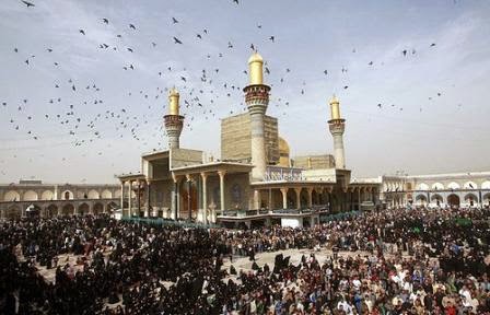
Iraq - The Wide Worlds Snaps

President: Fouad Massoum (2014)
Prime Minister: Haider al-Abadi (2014)
Land area: 167,556 sq mi (433,970 sq km)
Population (2014 est.): 32,585,692 (growth rate: 2.23%); birth rate: 26.85/1000; infant mortality rate: 37.53/1000; life expectancy: 71.42
Capital and largest city (2011 est.): Baghdad, 6.036 million
Largest cities: Mosul 1.494 million; Erbil 1.039 million; Basra 942,000; As Sulaymaniyah 867,000; Najaf 779,000
Monetary unit: U.S. dollar

Israel - The Wide Worlds Snaps

President-elect: Reuven Rivlin (2014)
Prime Minister: Benjamin Netanyahu (2009)
Land area: 7,849 sq mi (20,329 sq km);

total area: 8,019 sq mi (20,770 sq km)
Population (2014 est.): 7,821,850 (growth rate: 1.46%); birth rate: 18.44/1000; infant mortality rate: 3.98/1000; life expectancy: 81.28
Capital and largest city (2009 est.): Jerusalem, 791,000 Note: Israel proclaimed Jerusalem as its capital in 1950, but the U.S., like nearly all other countries, maintains its embassy in Tel Aviv.
Other large cities: Tel Aviv-Yafo 3.381 million; Haifa 1.054 million
Monetary unit: Shekel

Jordan - The Wide Worlds Snaps

Ruler: King Abdullah II (1999)
Prime Minister: Abdullah Ensour (2012)
Land area: 34,286 sq mi (88,802 sq km);

total area: 34,495 sq mi (89,342 sq km) excludes West Bank
Population (2014 est.): 7,930,491 (growth rate: 3.86%); birth rate: 25.23/1000; infant mortality rate: 15.73/1000; life expectancy: 74.1
Capital and largest city (2011 est.): Amman, 1.179 million
Monetary unit: Jordanian dinar
National name: Al-Mamlaka al-Urduniya al-Hashimiyah
Current government officials
Languages: Arabic (official), English

Kuwait - The Wide Worlds Snaps

Emir: Sheik Sabah al-Ahmad al-Jabir al-Sabah (2006)
Prime Minister: Sheikh Jabir al-Mubarak al-Hamad al-Sabah (2011)
Total area: 6,880 sq mi (17,819 sq km)
Population (2014 est.): 2,742,711 (growth rate: 1.7%); birth rate: 20.26/1000; infant mortality rate: 7.51/1000; life expectancy: 77.64
Capital (2011 est.): Kuwait, 2.406 million
Monetary unit: Kuwaiti dinar (KD)
National name: Dawlat al-Kuwayt
Current government officials
Languages: Arabic (official), English

Lebanon - The Wide Worlds Snaps

President: Tammam Salam (acting) (2014)
Prime Minister: Tammam Salam (2014)
Land area: 3,950 sq mi (10,230 sq km);

total area: 4,015 sq mi (10,400 sq km)
Population (2014 est.): 5,882,562 (growth rate: 9.37%); birth rate: 14.8/1000; infant mortality rate: 7.98/1000; life expectancy: 77.22
Capital and largest city (2011 est.): Beirut, 2.022 million
Monetary unit: Lebanese pound


Oman - The Wide Worlds Snaps

Sultan: Qabus ibn Sa'id (1970)
Total area: 82,031 sq mi (212,460 sq km)
Population (2010 est.): 2,967,717 (growth rate: 1.9%); birth rate: 23.9/1000; infant mortality rate: 16.8/1000; life expectancy: 74.1; density per sq mi: 15
Capital (2003 est.): Muscat, 797,000 (metro. area), 54,800 (city proper)
Monetary unit: Omani rial


Qatar - The Wide Worlds Snaps

Emir: Sheikh Tamim ibn Hamad Al Thani (2013)
Prime Minister: Sheikh Abdullah ibn Nasser ibn Khalifah Al Thani (2013)
Total area: 4,416 sq mi (11,437 sq km)
Population (2014 est.): 2,123,160 (growth rate: 3.58%); birth rate: 9.95/1000; infant mortality rate: 6.42/1000; life expectancy: 78.38; density per sq mi: 455
Capital (2011 est.): Doha, 567,000
Monetary unit: Qatari riyal


Saudi Arabia - The Wide Worlds Snaps

Sovereign: King Abdullah (2005)
Land area: 829,995 sq mi (2,149,690 sq km)
Population (2014 est.): 27,345,986 (growth rate: 1.49%); birth rate: 18.78/1000; infant mortality rate: 14.58/1000; life expectancy: 74.82; density per sq mi: 31
Capital and largest city (2011 est.): Riyadh, 5.451 million
Other large cities: Jeddah, 3.578 millioin; Makkah (Mecca), 1.591 million
Monetary unit: Riyal

Syria - The Wide Worlds Snaps

President: Bashar al-Assad (2000)
Prime Minister: Riyad Farid Hijab (2012)
Land area: 71,062 sq mi (184,051 sq km);

total area: 71,498 sq mi (185,180 sq km)
Population (2014 est.): 17,951,639 (growth rate: -9.73%); birth rate: 22.76/1000; infant mortality rate: 15.79/1000; life expectancy: 68.41; density per sq mi: 306.5
Capital (2011 est.): Damascus, 2.65 million
Other large cities: Aleppo, 3.164 million; Hims, 1.369 million; Hamah, 933,000
Monetary unit: Syrian pound

United Arab Emirates - The Wide Worlds Snaps

President: Sheikh Khalifa bin Zayed al-Nahyan (2004)
Prime Minister: Sheikh Muhammad ibn Rashid al-Maktoum (2006)
Total area: 32,278 sq mi (83,600 sq km)
Population (2014 est.): 5,628,805 (growth rate: 2.71%); birth rate: 15.54/1000; infant mortality rate: 10.92/1000; life expectancy: 77.09; density per sq mi: 256
Capital (2012 est.): Abu Dhabi, 942,000
Largest city: Dubai, 1.978 million
Monetary unit: U.A.E. dirham

Yemen - The Wide Worlds Snaps

President: Abdel Rabbo Mansour Hadi (2012)
Prime Minister: Khaled Bahah (2014)
Total area: 203,849 sq mi (527,969 sq km)
Population (2012 est.): 24,771,809 (growth rate: 2.575%); birth rate: 32.57/1000; infant mortality rate: 53.5/1000; life expectancy: 64.11; density per sq mi: 115.7
Capital and largest city (2003 est.): SanaĆ”, 1,937,451
Other large cities: Aden, 568,700; Hodiedah, 426,100; Tiaz, 317,600
Monetary unit: Rial


Tags: West Asia pictures, West Asia snaps, The Wide Worlds Snaps, West Asia - The Wide Worlds Snaps,Asia beautifull countries,

Friday, 28 November 2014

Yemen - The Wide Worlds Snaps

President: Abdel Rabbo Mansour Hadi (2012)
Prime Minister: Khaled Bahah (2014)
Total area: 203,849 sq mi (527,969 sq km)
Population (2012 est.): 24,771,809 (growth rate: 2.575%);

Birth rate: 32.57/1000; infant mortality rate: 53.5/1000; life expectancy: 64.11; density per sq mi: 115.7
Capital and largest city (2003 est.): SanaĆ”, 1,937,451
Other large cities: Aden, 568,700; Hodiedah, 426,100; Tiaz, 317,600
Monetary unit: Rial


The history of Yemen dates back to the Minaean (1200–650 B.C. ) and Sabaean (750–115 B.C. ) kingdoms. Ancient Yemen (centered around the port of Aden) engaged in the lucrative myrrh and frankincense trade. It was invaded by the Romans (1st century A.D. ) as well as the Ethiopians and Persians (6th century A.D. ). In A.D. 628 it converted to Islam and in the 10th century came under the control of the Rassite dynasty of the Zaidi sect, which remained involved in North Yemeni politics until 1962. The Ottoman Turks nominally occupied the area from 1538 to the decline of their empire in 1918.
The northern portion of Yemen was ruled by imams until a pro-Egyptian military coup took place in 1962. The junta proclaimed the Yemen Arab Republic, and after a civil war in which Egypt's Nasser and the USSR supported the revolutionaries and King Saud of Saudi Arabia and King Hussein of Jordan supported the royalists, the royalists were finally defeated in mid-1969.
The southern port of Aden, strategically located at the opening of the Red Sea, was colonized by Britain in 1839, and by 1937, with an expansion of its territory, it was known as the Aden Protectorate. In the 1960s the Nationalist Liberation Front (NLF) fought against British rule, which led to the establishment of the People's Republic of Southern Yemen on Nov. 30, 1967. In 1979, under strong Soviet influence, the country became the only Marxist state in the Arab world.
The Republic of Yemen was established on May 22, 1990, when pro-Western Yemen and the Marxist Yemen Arab Republic merged after 300 years of separation to form the new nation. The poverty and decline in Soviet economic support in the south was an important incentive for the merger. The new president, Ali Abdullah Saleh, was elected by the parliaments of both countries.


Tags: Yemen pictures,Yemen snaps,Yemen cities pictures,Yemen country,wide world snaps,Yemen - The Wide Worlds Snaps,The Wide Worlds Snaps,